Evacuations from High-Risk Locations Call +44 (0)1202 308810 or Contact Us →
Typhoon Maria
10 Jul 2018
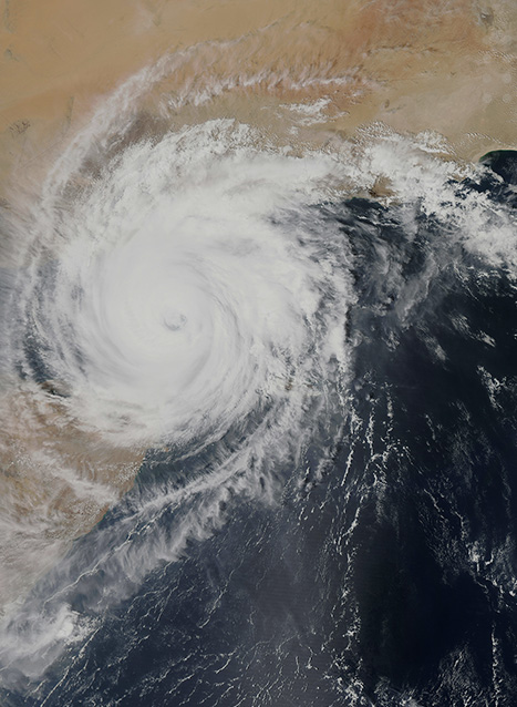
Super-typhoon Maria is a category-four storm in the south of the East China Sea, heading west-northwest towards northern Taiwan and mainland China with sustained windspeeds of up to 220 kph (136 mph). The eye of the storm is over 50km wide, with a total diameter of over 500km.
Key Points
- Typhoon Maria is a category five super-typhoon, with sustained windspeeds of at least 220 kilometres per hour (136 mph) with gusts of up to 244 kph (151 mph).
- The storm is expected to strike northern Taiwan on the evening of the 10 July and mainland China on the morning of 11 July.
Situational Summary
Environmental: Super-typhoon Maria is a category-four storm in the south of the East China Sea, heading west-northwest towards northern Taiwan and mainland China with sustained windspeeds of up to 220 kph (136 mph). The eye of the storm is over 50km wide, with a total diameter of over 500km.
Maria is likely to pass south of Japan’s Okinawa and the surrounding islands; however these islands are still likely to suffer severe rainfall and high winds. The northern fringes of the storm struck southern Japan over the past 24 hours, resulting in extreme flooding and landslides which have killed over 100 people, Okinawa is likely to suffer more extreme conditions.
Northern Taiwan and Taipei is likely to bear the brunt of the storm and the associated adverse sea conditions. It is estimated that lowland areas of Taiwan may see between 100mm-200mm of rain, within 24 hours, while mountainous areas could experience between 200mm and 400mm. Landfall on Taiwan is expected in the afternoon of the 10 July local time. The storm is expected to clear the island by the early hours of the 11 July.
Maria is highly likely to make landfall in eastern China in the early hours of 11 July. Local officials have issued a yellow alert in the coastal provinces of Fujian, Zhenjiang, Jiangxi and Hunan. The impact of the storm in these regions is likely to be significantly reduced compared to that in Taiwan, and the storm is likely to degrade rapidly once it is fully over land. Heavy rainfall is likely to continue as it pushes as far inland as the city of Nanping by 12 July.
Maria is the fourth Typhoon of the 2018 season, but the first category five super typhoon since 2016 and the largest to make landfall in China or Taiwan for several years. Both Taiwan and eastern China have been hit by typhoons before and can be expected to have measures in place to respond to the crisis. All effected regions are likely to experience extensive flooding, high winds, sea swells, and widespread disruption to land, sea, and air travel. Although Taiwan is likely to be struck by more severe weather, the poorer standards of infrastructure in China’s coastal regions mean that the effects in both countries are likely to be devastating. In either country, non-hardened structures are likely to suffer severe damage, and loss of life is highly likely.