Evacuations from High-Risk Locations Call +44 (0)1202 308810 or Contact Us →
Hurricane Maria Hits the Caribbean – Environmental Risks
19 Sep 2017
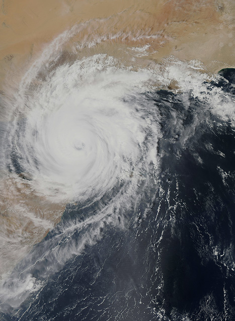
Hurricane Maria is currently a Category Five storm in the northeastern Leeward Islands, but is heading west-northwest towards the rest of the Caribbean. The hurricane has increased in power and windspeed rapidly, going from a Category Two to Five in less than 18 hours. Maria has hit some of the northern Leeward Islands such as Dominica, Guadeloupe, and Montserrat head on at Category Five (the most severe level). It did reduce in to a Category Four storm before returningto a Category Five level.
Key Points
- Hurricane Maria is a Category Five hurricane currently situated in the northeastern Leeward Islands in the Caribbean.
- Maria has sustained windspeeds of around 250 km/h (160 mph) with gusts of 280 km/h (170 mph) and is moving west-northwest at 13 km/h (9 mph).
- The storm is predicted to hit many islands which were devastated by Hurricane Irma, and is expected to make landfall on Puerto Rico late on 19 September or early on 20 September.
Situational Summary
Environmental: Hurricane Maria is currently a Category Five storm in the northeastern Leeward Islands, but is heading west-northwest towards the rest of the Caribbean. The hurricane has increased in power and windspeed rapidly, going from a Category Two to Five in less than 18 hours. Maria has hit some of the northern Leeward Islands such as Dominica, Guadeloupe, and Montserrat head on at Category Five (the most severe level). It did reduce in to a Category Four storm before returning to a Category Five level.
Maria is predicted to head towards Anguilla, the Virgin Islands and make landfall in Puerto Rico late on 19 September or early the following day. This could mark the strongest storm to hit the US territory of Puerto Rico in 85 years. These aforementioned islands are the most likely to be impacted, after which Maria is predicted to follow a west-northwest path, grazing the coast of Dominican Republic, and then hitting Turks and Caicos island head on. There is still a risk that Maria could make landfall in the United States but it is difficult to predict this far ahead. If it does hit the United States, landfall is likely to be made around 26 or 27 September. In the areas that are hit, heavy rain, flooding, storm surges, and strong winds are expected.
Hurricane Maria is the sixth hurricane to threaten North and Central America in seven weeks. Many islands in the Caribbean are still recovering from the devastating effects of Hurricane Irma which struck around two weeks ago. Hurricane Maria is travelling slowly for a hurricane, meaning the areas in its path are exposed to its potentially catastrophic effects for longer.
A Hurricane Warning (hurricane conditions are expected within 36 hours) is in effect for:
Guadeloupe; Dominica; St. Kitts, Nevis; Montserrat; U.S. Virgin Islands; British Virgin Islands; Puerto Rico; Culebra; and Vieques.
A Tropical Storm Warning (tropical storm conditions are expected within 36 hours) is in effect for:
Antigua and Barbuda; Saba and St. Eustatius; St. Maarten; Anguilla; St. Lucia; and Martinique
A Hurricane Watch (hurricane conditions are possible within 48 hours) is in effect for:
Saba and St. Eustatius; St. Maarten; St. Martin and St. Barthelemy; Anguilla; Isla Saona to Puerto Plata
A Tropical Storm Watch (tropical storm conditions are possible within 48 hours) is in effect for:
St. Vincent and the Grenadines; West of Puerto Plata to the northern Dominican Republic-Haiti border.
SECURITY ADVICE
EnvironmentHighTravellers are advised to pay close attention to weather updates in the coming days to see how the direction and the intensity of Maria stands to change. Any travellers in the Caribbean, and in particular the Leeward Islands, Puerto Rico, and the Turks and Caicos Islands, should ensure they have hurricane plans in place, especially considering it is the height of the hurricane season.
If and when Maria makes landfall, it is advisable to avoid low lying areas because of the increased chances of flooding from storm surges and heavy rain. It is also advised to cover windows with storm shutters and make any alterations to accommodation to ensure protection, such as sandbags around doorways if flooding is a concern. At present, it is best for people to stay in their current location, unless an evacuation order has been issued or the structure has been damaged by previous hurricanes. Many Caribbean islands have ordered curfews, strongly advising people to stay in their homes. If staying inside, a room without windows is a preferable choice. If flooding occurs, or could occur, the mains power system should be switched off. It is also important to keep a radio in your presence, so you can be updated on when it is safe to leave a dwelling. Torches should be used, rather than lamps or candles, to prevent unintended fires. If your dwelling is being destroyed while you are in it, get in the bath or under a mattress.
Food supplies should consist of non-perishable items and be enough to support each family member for at least three days. One gallon of water per day per person is also recommended. Travellers should have an emergency medical kit with them. It is also advisable that families and loved ones are informed of your current position and kept regularly updated so that they can send assistance in case they lose contact with you. Travellers who are on holiday should follow the instructions of the hotel authorities as they will have their own hurricane plans and formalities.
Travellers may wish to use travel-tracking technology with an intelligence feed to stay updated of storm and security related
events. Travellers utilising air travel in the region over the coming week should contact their airline to understand what impact
Hurricane Irma has on any planned flights.
For more, and to follow the path of the storm, see the United States’ National Hurricane Centre website at:
http://www.nhc.noaa.gov/.